Create interactive maps, diagrams, and images online
MapsAlive lets you make any image interactive. Your “map” can be anything: a floor plan, org chart, schematic, photograph, drawing or anything you like. An interactive map can display photos and text, play videos or sound, and even draw routes between locations on the map. Try it yourself using the interactive bird diagram below.

Free 30 day trial
No download and no credit card needed
Make any floor plan interactive
Interactive floor plans let buyers see a home at a glance: how the rooms are laid out, how big they are, and where windows and doors are located. Move your mouse over the green arrows to see a photo taken from that location. Use the nav button in the center of the banner to visit the second floor, a see gallery of additional photos, or read the listing information.

Make any photograph interactive
You can make any image interactive with MapsAlive. The sample below is not a map in the traditional sense of the word, but it comes alive when you add hotspots that display text and other images when you touch or mouse over the points of interest.
Make any diagram interactive
You can make any diagram interactive with MapsAlive. The interactive diagram below lets you explore the internal anatomy of the honey bee.
Make an interactive gallery of images
Quickly create an interactive gallery of photos, drawings, or artwork. When you add images to a gallery, MapsAlive automatically creates thumbnails and places them on a background.
MapsAlive works great on mobile devices
MapsAlive automatically switches to mobile mode on small devices and behaves like a mobile app. But because it’s running in a browser, people don’t need to download an app to use the interactive maps, diagrams, floor plans, and images you create.

Why use MapsAlive?
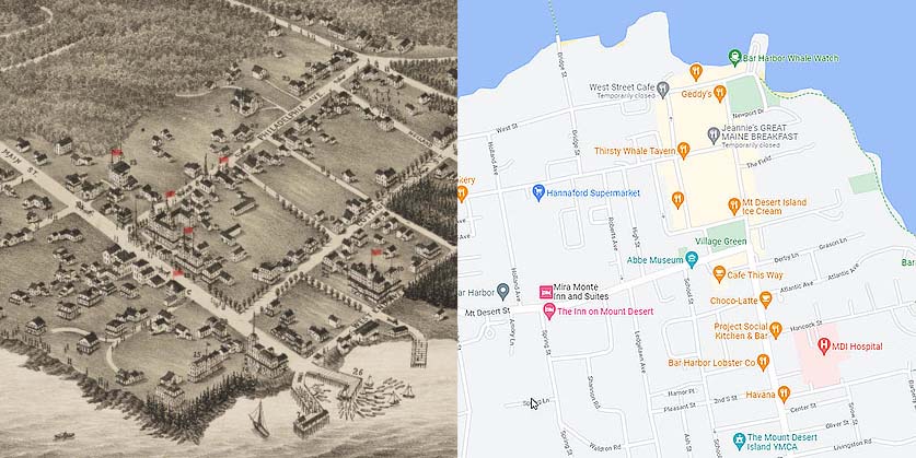
To understand why people use MapsAlive, just compare these two maps of downtown Bar Harbor, Maine: A hand-drawn bird’s eye view and a Google Map. Both can be interactive, but with MapsAlive you don’t have to use the same street maps over and over. You can choose any image for a map and it won’t contain advertising or other information that detracts from your interactive content.
MapsAlive is a product of AvantLogic Corporation